The City of Joondalup required an inventory collection of all trees within its 97 km2 jurisdiction as a key input to the City’s asset management, environmental, sustainability and arboriculture programs. Spatial information to be gathered included location (coordinates), geometry (canopy height, diameter, area), and spatial relationships (position within a reserve, proximity to power lines and street lights, for example). In addition, other zonal attributes related to roads, reserves, wards and tenure were required to be associated with each tree record.
Traditionally a task such as this would be completed by teams of on-ground data collectors, but with nearly 10,000 km of urban streets to traverse and more than 50,000 trees to inventory in road reserves alone, foot surveys would have taken hundreds of personnel days.
The City of Joondalup engaged Astron to apply a remote sensing approach which had the following clear advantages:
- Minimal safety risks (i.e. traffic management) with the only necessary on-ground work being a data validation test in a suburban park.
- Comprehensive coverage, with every single tree in the City inventoried including private property and reserves.
Four-band aerial imagery was acquired in the form of original individual image frames from an external data provider. We then applied photogrammetry techniques to produce from this a high-resolution 3D point cloud of the entire City. A digital surface model was then generated, and classification techniques were used to extract the ground-level elevation model. From these two models we produced a digital height model.
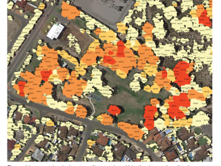
Vegetation was separated from other structures using machine-learning classification based on the Normalised Difference Vegetation Index, which is calculated using the near-infrared and red image bands. Then trees were separated from low-level vegetation using their height characteristics. Boundaries between individual trees were established in a method known as segmentation. These trees were then turned into vector objects, each with a unique identification number, which then formed the basis of the tree inventory database. We then used GIS tools to calculate geometrical, spatial and positional parameters for each of the several hundred thousand trees.
The result was a comprehensive census of trees in the City of Joondalup. The City is able to select individual or groups of trees according to their characteristics to inform asset and arboriculture management programs, and as a basis for strategic planning. The database also forms a valuable baseline from which change over time may be evaluated.
Height values calculated in our study were validated on-ground. Tree heights were measured from the ground using a laser rangefinder, and these heights were then compared with those of our model. For trees up to 20 m in height, standard errors fell around 0.93 m, which dropped to 0.77 m for trees below 5 m. These margins of error are very close to the sensitivity to the ground measurements, where injudicious selection of the top-most branches, or variations in wind effects, can lead to a significant variation in the measured tree height. Our results, therefore, represent an outcome as accurate as conventional measurements.